Itinéraire Gravel n°28 - De l'étang de le bonde à Fontjoyeuse - EN
This little loop is perfect for discovering the charming villages of the South Luberon. The little extra: enjoy a relaxing moment by the Etang de la Bonde!

Via a succession of small roads and country lanes, the route skirts the Etang de La Bonde and then climbs to Cabrières d'Aigues. After passing through the village, the route climbs a final steep incline above the château. Then, still on tracks and surfaced roads, the route descends to La Motte-d'Aigues, then climbs gently back up to the Mirail water intake. From here, the itinerary heads due south, reaching the hamlet of Fontjoyeuse below, taking the D27 for 200 m, then rolling down beautiful tracks to the banks of the Riou. Here, a large ramp at 12%, fortunately surfaced, climbs up to the foothills of Castellas, then drops down to Saint-Martin-de-la-Brasque. After crossing the village, the slightly downhill final stretch to Etang de la Bonde is on the paved Chemin de la Loine.
Picture gallery


Contact & informations
Itinéraire Gravel n°28 - De l'étang de le bonde à Fontjoyeuse - EN
Write us
Add to favorites
Discover our free and easy to access tool to create your bike route in just a few clicks!
Create your bike route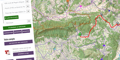


Order your free brochure
Discover our editions of the Luberon south side to prepare your weekend and holidays: guide, accommodation, hiking...
Order